
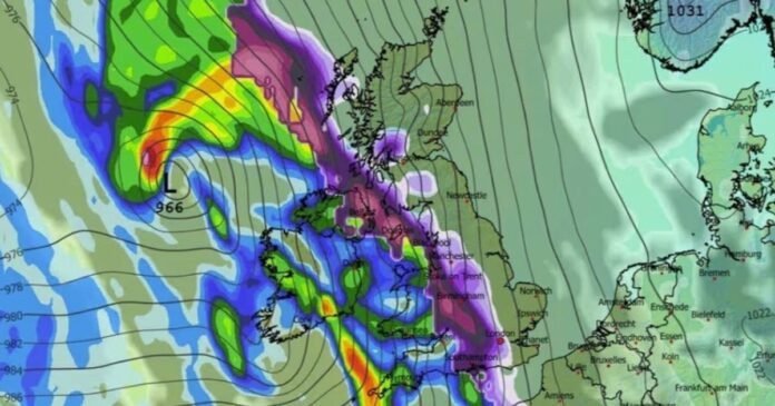

The latest forecast from the Met Office suggests the possibility of a new cold weather system heading towards the UK, reminiscent of the previous ‘Beast from the East’ blizzard.
Maps provided by WX Charts indicate a significant weather pattern with a high-pressure system from Scandinavia bringing cold air to the UK by around February 8. This cold air is expected to collide with a band of rain, resulting in substantial snowfall similar to the 2018 ‘Beast from the East’ snowstorm.
Forecasts indicate that heavy snowfall is anticipated in southern England by midnight, while a wide band of heavy snow is predicted to move across the Midlands, Wales, northern England, and Scotland.
Cities such as Liverpool, Birmingham, Newcastle, and Edinburgh are likely to be directly impacted by the winter storm as two weather systems merge, as reported by the Liverpool Echo.
Snow coverage maps for February 17 show a widespread purple shading across the UK, indicating potential snow cover everywhere. The Scottish Highlands may experience the most significant snow accumulations, with up to 54cm (21 inches) possible.
Despite these forecasts, the Met Office’s long-range prediction suggests that wintry conditions will mainly affect the north of England and Scotland, particularly in higher altitude areas.
Over the period from Friday, February 6, to Sunday, February 15, the forecast mentions the likelihood of snow in northern England and Scotland as bands of rain move northward, encountering colder air.
The Met Office anticipates continued unsettled weather throughout the upcoming week and into the weekend. A yellow snow warning has been issued in eastern Scotland and the central belt, while areas like Cornwall, Devon, and Dorset may experience flooding due to heavy rainfall on saturated ground.
Meteorologist Alex Deakin highlighted the potential for flooding in certain regions due to saturated ground, with snow warnings also in place for areas in the northeast.
Tuesday’s weather forecast indicates cloudy conditions with rain, particularly heavy in the south and southwest, and possible snow in central and eastern Scotland. Some brighter intervals may occur in the northwest.
The weather is expected to remain changeable with occasional bright spells. Most regions will experience wet and sometimes windy conditions, with snow likely on northern hills.